Rivers, creeks, lakes, oceans, … are key components in the hydrological cycle. We use them for drinking, irrigation, transport , recreation,… and they also serve as a habitat for many plant and animal species. Unfortunately, many of the surface waters are under severe pressure. Just think about water pollution from oil and plastics, eutrophication, water extraction, droughts, floods, etc.
Luckily, remote sensing technology has evolved tremendously and offers many new solutions to keep track of our planet’s surface waters and provide information on their status. But how do we use technological innovations, big data and AI to develop or improve EO-based services?
Let us explain how we transform more than 20 years of knowledge and experience into a variety of operational services for water quality monitoring.
A story about Water & coast, iCOR, water quality monitoring, plastic pollution, WaterMonitor, MAPEO
UNDERSTANDING WATER SURFACE COLOURS SINCE THE YEAR 2000
As far back as the year 2000, we’ve been eager to exploit new technologies offered by hyperspectral and multispectral remote sensing. Our interest boosted when we were involved in the operation and data processing of the APEX airborne instrument, a high spectral and spatial resolution hyperspectral sensor to study many crucial subjects on Earth like air quality, biodiversity, and also water quality monitoring. At the time, we were preparing for APEX and were organizing the first hyperspectral flight campaigns using sensors such as CASI, Hymap…
These sensors record the reflectance of the earth surface in high detail in both the visual and infrared portion of the electromagnetic spectrum. Unlike most satellite data, which only record parts of the entire spectrum in broad spectral bands, these sensors allow us to look at the Earth in 3 dimensions (2 spatial dimensions and 1 spectral dimension). With this technology, we can better understand why the water looks blue, green or brown and where it comes from. This allows us to build algorithms for any type of sensor and platform (satellite and airborne) and to derive information products such as the turbidity of the water or the chlorophyll-a content.
HIGH-QUALITY ATMOSPHERIC CORRECTION FOR WATER SURFACES
Our goal has always been to provide high quality end products, the same quality as derived from field observations. What is crucial in this sense, is to remove the contribution from the atmosphere because it interferes with the reflectance obtained from the earth’s surface. Therefore, we started to develop our own atmospheric correction approach with a dedicated component for water surfaces. We built specific expertise on adjacency correction to reliably process data from coastal and inland waters and developed the atmospheric correction software iCOR. Today, the iCOR software is available to process drone images and is also made available as a plugin for the SNAP toolbox. It is used by international teams across the globe to process satellite data from Sentinel-2, Landsat-8 and Sentinel- 3.
Over the years, we have been specializing in deriving water quality products for inland, riverine and coastal waters. These waters are often referred to as optically complex, because there are different water constituents such as suspended sediments, organic matter and algae that all alter the reflectance observed by a remote sensor. Hence, deriving high quality quantitative information from these areas is a challenge. Again, a detailed representation of the spectral reflectance helps to build algorithms. It even helps us to find new insights as we found a new approach to derive turbidity in extremely turbid waters (think about waters such as the Scheldt river in Belgium and the Gironde river in France).
TRANSFORMING DATA AND KNOWLEDGE INTO PRODUCTS AND SERVICES
Working with airborne hyperspectral instruments also means dealing with gigabytes of data. So we had to find innovative ways to deal with the large amount of data and derive meaningful information from it. Hence, machine learning algorithms already found their way into the team. Today this expertise allows us to combine both spectral and AI approaches to develop applications for our users. It allows us to better exploit all the information content of the images and combine for instance the colour (the optical characteristics) as well as the spatial information such as specific shapes and structures of the water…
This knowledge and expertise built upon airborne hyperspectral remote sensing were consolidated into the development of operational solutions for processing satellite, airborne and drone data. With these developments, we can quickly answer the needs of our customers
By selecting and combining the suitable data, be it airborne, satellite and/or drone, with the right remote sensing technology we can collect data and turn that into objective information products and operational services for a variety of applications:
- Waterway management
- Eutrophication assessment
- Bathing water quality assessment
- Marine plastics /litter detection
- Dredging support
- Coastal infrastructure
- …
WALK THE TALK! TIME FOR SOME EXAMPLES
Time to give you some examples. Discover some of the products and operational services we’ve developed in the past few years to support our customers. These include environmental agencies and dredging companies.
WATER PROCESSOR
The water processor is a fully automated processor which turns Landsat-8, Sentinel-2 and Sentinel-3 satellite images into information maps and objective data products. The Water Processor offers several standard products such as turbidity, suspended sediment concentration, chlorophyll concentration and the attenuation coefficient. The atmospheric correction software ICOR is an integral part of the processor.
Garry Free, former scientific officer at the Environmental Protection Agency (Ireland), explains how they used EO data to monitor the ecological status of water bodies in one of our previous blogs ‘Keeping an ‘eye’ on our European waters’. In another blog, we showed how Sentinel-2 satellite data and the Water Processor were already used by the dredging community to map water quality and protect marine life. Discover more in the blog ‘Sentinel-2 to support dredging activities’.
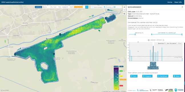
WATERMONITOR
The WaterMonitor is a user-friendly platform to monitor Chlorophyll-a in our Flemish water bodies. We developed this application for the Flanders Environment Agency (VMM) in collaboration with the EODaS programme (Earth Observation Data Science) of the Flanders Information Agency, NAZKA Mapps.
Sentinel-2 based Chlorophyll-a concentration maps show the spatial variation over a water body and how it varies over time (the satellite returns every five days). This can be used to complement field observations and better organize field data collection. Via the WaterMonitor you can easily access time series of Sentinel-2 based Chlorophyll-a concentration products and add user supplied Chlorophyll-a field data for comparison. Click here to discover more.
MAPEO WATER
MAPEO Water is a cloud-based platform to process drone images into water quality products. It allows users to organize drone flights, fly themselves or via a drone operator, and receive flight protocols developed within the H2020 MONOCLE project upon request. Uploading the data is done through the field software toolbox developed within VITO. This leads the user through the process in a set-by-step approach, including a quality checking. Immediately after uploading the drone data in the cloud, processing is triggered. The processing includes a direct georeferencing, calibration and skyglint correction (iCOR4drones). MAPEO Water allows you to derive similar products as retrieved from satellite observations, such as the turbidity and the chlorophyll-a concentration of the water. After completion, the results can be downloaded or visualised through GeoServer.
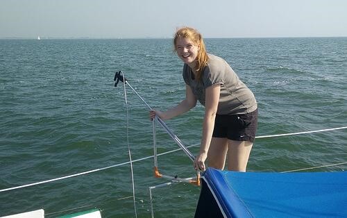
Drone monitoring of sediment plume generated by RV Simon Stevin operating in a turbid area of the Belgian sector of the North Sea (financed under Belspo Stereo III TIMBERS-project - contract number SR/00/381).
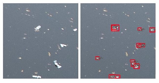
MARINE PLASTICS
The detection and identification of marine plastic litter is where all this expertise comes together. Knowledge on spectral properties of the water is combined with AI expertise to find to the best solution. Currently we are evaluating the use of drones and fixed cameras to monitor both individual plastic and accumulation zones in rivers and coastal areas. This expertise enables us to contribute to the IOCCG (International Ocean Colour Coordinating Group) task force on remote sensing of marine litter and debris.
BEYOND WATER QUALITY MONITORING
The most important aspect to keep in mind is to provide our customers with a complete solution. And water quality mapping is just a part of it all. By connecting with other experts, within VITO and also with industrial partners, we can provide our customers with the solutions they need. We keep track of the latest technological improvements and integrate these into our research and products to improve our expertise and expand our offer. From beach morphology over coastal infrastructure to ship detection. Stay tuned to discover more.