Visualising 250 years of landscape evolution using AI
The Institute for Nature and Forest Research (INBO), the Agency for Agriculture and Fisheries, Digital Flanders, and VITO have combined their expertise to map historical land use. This provides a literal depiction of the changes in the landscape of Flanders and Brussels since the end of the 18th century and enables researchers to quantify them.
The Ferraris maps, completed before 1778, and the topographic maps of 1873 and 1969 can be consulted online through the geoportals Geopunt (Flemish government) and Cartesius (National Geographic Institute). However, the map display on these geoportals does not allow for the calculation of the former areas of heathland, forest, arable land, grassland, or other land uses. AI helped recognise the legends of these historical maps and digitise patches of the same land use. This enabled the land use in 1778, 1873, and 1969 to be calculated and compared with current land use. What's more, the maps can now be overlaid to analyse changes in land use.
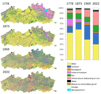
The analyses reveal significant changes in Flanders over the past centuries:
- Fields and grasslands together accounted for over 65% of Flanders until 1969, but their share decreased to 52% by 2022. This decline is primarily attributed to the increase in infrastructure, buildings, and gardens.
- Between 1873 and 1969, many fields were converted to grasslands, more than doubling their area from 13% in 1873 to over 28% in 1969. This shift was a result of a major agricultural crisis at the end of the 19th century, where the import of cheap grain led to a shift from arable farming to livestock farming. The increase in orchards during this period, from 2% to 4%, can also be linked to this.
- The proportion of heathland and coastal dunes decreased significantly, from 12% at the end of the 18th century to 1% in 2022. Afforestation was the main cause of this decline in the 19th century, while between 1873 and 1969, land reclamation for agriculture also played a significant role. More than half of the coastal dunes disappeared due to the increase in infrastructure, buildings, and gardens.
- The proportion of forests remained consistently around 10% over the past centuries. However, behind this seemingly stable figure, there were significant shifts balancing each other out. Forests were cleared for agriculture in the west and south of Flanders, while a similar area of heathland was afforested in the Kempen region.
- Since the 18th century, the area occupied by infrastructure, buildings, and gardens has increased more than fivefold, from 5% to 27%. This increase accelerated after 1873, at the expense of all other land use classes.
- The area of water increased from 2% to 3% after 1969, due to the construction of port docks and sand, clay, and gravel extraction. However, the area of marshes and intertidal lands (salt marshes, mudflats, or beaches) decreased from 1.3% in 1778 to 0.4% in 2022.
Due to this dynamic, only 20% of the area of Flanders remained unchanged in land use over the past 250 years in 2022. The majority of this consists of fields (14.2% or 194,000 ha). Historically permanent grasslands (2.5%), forests (1.5%), heathland (0.5%), water bodies (0.4%), and orchards (<0.1%) cover a much smaller area.
The maps depicting the evolution of historical land use are highly valuable for determining the significance of landscapes for heritage values, biodiversity, ecosystem services, or agricultural use. They enable the identification of historical agricultural areas, explanation of carbon stocks in grasslands, identification of disappeared marshes and river arms with water retention functions, and distinction between old forests with high biodiversity and more recently established forests. These maps can be useful for supporting discussions and can be used by policymakers for various actions (supported by Flemish and/or European funds) impacting spatial planning.
Consult the report
The maps will be shared via Geopunt, and the full report can be accessed through the button below.
De Keersmaeker L., Roggemans P., Ghysels T., Poelmans L., Buskens I., Petermans T., Tallir S., Van Valckenborgh J.(2024). Digitalisatie van historisch landgebruik en analyse van landgebruiksveranderingen in Vlaanderen (1778-2022). Resultaten van deep learning (AI) beeldclassificatie toegepast op drie historische kaarten. Rapporten van het Instituut voor Natuur- en Bosonderzoek 2024 (16).