35 years of geo-intelligence: from data to decisions
How is land use evolving in conflict zones? Which ecosystems are meeting the targets of the European Nature Restoration Law? Where are crops at risk of failing due to drought?
Questions such as these require reliable, up-to-date data on a scale that no field team can keep up with. Satellites, however, can.
For 35 years, VITO has been converting satellite data into actionable insights for policymakers, public authorities and businesses. What began with the first global vegetation maps in 1998 has grown into an international ecosystem of geospatial platforms, AI models and applications that support regional and European policy objectives relating to nature, climate, agriculture and trade.
From vegetation maps to continuous monitoring
In 1998, VITO developed the first consistent global vegetation maps based on satellite data. That pioneering work laid the foundations for a central role within Copernicus, the European Earth observation programme, and the associated Sentinel satellites.
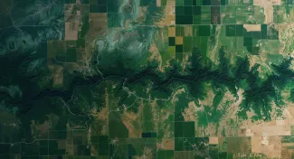
Since then, Earth observation has evolved significantly. Within the ESA initiatives WorldCover and WorldCereal, VITO played a leading role in developing the most detailed and uniform global land-cover classification maps ever produced.
Thanks to artificial intelligence and cloud computing, these maps make it possible to systematically monitor changes in land use worldwide and across the seasons, down to a resolution of ten metres. This provides policymakers with consistent and up-to-date information for, amongst other things:
- detecting deforestation under the EU Deforestation Regulation (EUDR),
- verifying agricultural areas under the Common Agricultural Policy,
- monitoring ecosystems in accordance with the European Nature Restoration Law.
Whereas field surveys are often costly and time-consuming, satellite data enables continuous and objective monitoring on a large scale.
Making data accessible
As the volume of satellite data increased, the focus shifted from the data itself to access to it and the capacity to work with it. That is why VITO invested in open, scalable platforms, including Terrascope, the Belgian Earth observation platform that VITO manages on behalf of the federal government (BELSPO). It provides more than 43,000 users from the research community, government, industry and education with access to Copernicus satellite data, cloud computing and analysis tools such as openEO.
This approach was recognised in 2026 with two BeGeo Awards: one for capacity building and education, and another for practical applications in areas such as air quality, agriculture and water management.
VITO has also developed specialised platforms for agriculture, including:
- WatchITgrow, which provides farmers with real-time insights into their crops and offers data-driven cultivation advice;
- MAPEO, which helps breeding companies to develop climate-adaptive varieties more quickly using drones, hyperspectral imaging and AI analysis.
Seeing details with hyperspectral technology
New generations of sensors are revealing more and more. Whereas traditional satellites record only a limited number of colour bands, hyperspectral sensors measure hundreds of wavelengths simultaneously. This reveals characteristics of vegetation, soil and water that remain hidden in conventional images, creating new opportunities for precision agriculture, pollution detection, soil research and biodiversity monitoring.
VITO has built up its expertise in this field through initiatives such as APEX (Airborne Prism EXperiment), one of Europe’s most advanced airborne systems. A new milestone followed at the end of 2025 with the launch of the Belgian satellite NAHLA, equipped with the IPERLITE instrument.
From an orbit at an altitude of 510 kilometres, IPERLITE collects hyperspectral images, which VITO processes via its own ground segment into calibrated datasets and makes available via Terrascope.
Reliable insights at scale
More sensors generate more data. To process this data efficiently, VITO has developed the following technologies, amongst others:
- CORSA compresses Earth observation data without any significant loss of quality, enabling AI analyses to take place closer to the sensor and making optimal use of satellite capacity.
- CALIBREO automates the calibration and quality control of remote sensing data, a crucial prerequisite for the consistent time series required for policy monitoring and regulatory reporting.
Verifiable and auditable data are indispensable for regulatory frameworks such as the CSRD (Corporate Sustainability Reporting Directive) and the EU Deforestation Regulation. Satellite-based monitoring provides an independent and reproducible source of information that complements – and in some cases replaces – field checks.
Applications that make a difference
Geo-intelligence is not an abstract technology. Its applications are already making a difference today in nature conservation, disaster response, infrastructure and coastal management, and urban planning.
- Through the INCA framework (Integrated Natural Capital Accounting), VITO makes ecosystem services measurable, from carbon sequestration and biodiversity pressure to the impact of land-use changes. These insights support reporting under the European Nature Restoration Law and national climate plans.
- By combining satellite imagery with local sensor data, VITO can detect floods, wildfires and pollution more quickly than is possible with traditional monitoring methods. In the field of maritime safety, ultraviolet cameras reveal oil pollution that remains undetected by standard optics. This provides emergency services with crucial information exactly when they need it.
- For infrastructure, coastal management and urban planning, VITO develops applications based on LiDAR (laser scanning technology), sonar, thermal imaging and mobile sensors. Through the MAPEO digital laboratory, organisations can also develop bespoke solutions without having to build the entire technical infrastructure themselves.
Geo-intelligence for everyone
A new development is emerging today. Generative AI and AI agents are making it possible to make complex satellite analyses accessible to users without in-depth technical expertise.
Just as weather apps translate raw satellite and radar data into understandable forecasts, geo-intelligence platforms can directly support policy analysts, urban planners and environmental advisers by providing answers to complex spatial questions.
With reliable data, calibrated analyses and open platforms, VITO is continuing to build that future. In this way, geo-intelligence is evolving from a specialised technology into an indispensable digital infrastructure for policy, research and civil safety.