3D seismic survey campaign for geothermal energy
In September 2024, vibration trucks will once again be circulating in Dessel and Mol and, for the first time, in Retie. VITO is deploying the trucks to map the deep subsoil in the wide surroundings of the Balmatt site in Mol.
Why is VITO investigating the deep subsoil?
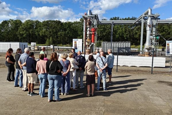
VITO is investigating whether heat from the deep subsoil can be used to heat houses and other buildings in a sustainable way. To this purpose, VITO has built a pilot plant on its own site in Mol. The plant pumps hot water from the deep subsoil, more than three kilometres deep. That water comes from the so-called production well, located vertically under the Balmatt site. Heat is extracted from that water in the geothermal power plant. VITO wants to use it to heat the buildings of VITO, SCK and part of BelgoProcess. The cooled water is returned to the deep subsoil and enters another well, the so-called injection well. That well is drilled obliquely from the Balmatt site and is located roughly below Zandvliet in Dessel.
During the start-up period of the geothermal power plant in 2018-2019 and 2021-2022, tremors occurred in the deep subsoil. The occurrence of tremors is a known and expected risk of geothermal heat extraction. VITO has taken this into account in the Balmatt project and incorporated a safety system for this purpose. This so-called traffic light system is based on the extensive seismometer network VITO has built in Dessel and Mol. The traffic light system should prevent tremors causing damage to surrounding infrastructure. Twice, in June 2019 and November 2022, a tremor has caused damage to houses in the area. Those affected were compensated by VITO's insurance for this. More info on the traffic light system can be found here.
VITO maintains its belief that deep geothermal energy can contribute to keeping energy sustainable and affordable in the future. But preferably without quakes, of course. The new program which VITO is currently developing on deep geothermal heat therefore focuses even more on preventing damage caused using deep geothermal heat. And VITO is also setting up a dialogue with stakeholders in the region to this end.
The seismic survey campaign is a first step in this process: mapping the deep subsoil in even more detail to gain insight into the presence, location, direction, and size of natural faults between the earth layers. After all, it is these faults that determine where and when quakes can occur and what force they can reach. Such information is therefore needed to assess quake risk more accurately and to take proactive action.
Hence, the results of the seismic survey could, on the one hand, lead to adjustments to the injection point, to send the cooled water back to a place in the deep subsoil where the risk of quakes is lower. On the other hand, the researchers will use the results to further refine the geothermal power plant's traffic light system, which will also reduce the risk of quakes.
What is the principle of seismic measurements?
Seismic measurements use the propagation and reflection of sound waves in the subsoil, similar to sonar in water. The waves are artificially generated by specialised vibration vehicles, which create vibrations on the earth's surface. The sound waves, caused by those vibrations, propagate in the subsoil. When the waves reach the interface between two different earth layers, part of them will be reflected. At the surface, sensors measure after how many seconds the signal returns. This gives a good estimate of the depth of the line between those two earth layers.
The measurement is not done once, but several times and at several locations. This is to obtain a sufficiently strong signal and filter out the background noise.
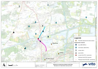
The currently planned measurements will be carried out over an area of over 40 km², covering a large part of the territory of Dessel and Mol as well as part of the territory of Retie. This will allow the researchers to examine how the depth of the geological layers varies over the area and how the subsoil is built up. Do the layers lie horizontally, or do they incline in a particular direction? Are the layers 'staggered' by a fault?
In the past, VITO has already performed such surveys along measurement trajectories in Mol and Dessel (2010 and 2020). However, the trajectories only provide information on the subsoil directly below the trajectory, but not to its left and right. The planned survey campaign remedies this by carrying out the measurements over the entire area.
On the map you can see where the measurements are planned.

How is the survey carried out in practice?
-
The field works are started by surveyors who determine the exact positions of the points where we will vibrate and the locations of the vibration meters (sensors or geophones). They mark these points with stakes or paint. They consider the location of buildings (houses) and pipes (e.g. water, gas).
-
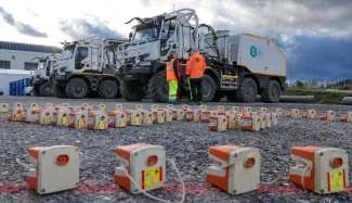
In the next step, sensors are placed. Vibrations are recorded with vibration meters or sensors, which are placed every 20 m along the route, preferably in the roadside. The fist-sized devices are fixed into the ground with a pin. The sensors are placed at the beginning of the measurement campaign and removed again when all measurements are completed. Altogether, they will remain in each location for 3-4 weeks.
-
During the campaign, the sensors will be checked that they are still properly placed and working correctly.
-
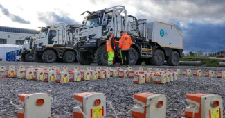
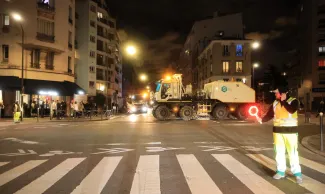
The vibrations themselves are carried out using specially equipped trucks. A vibration plate is mounted on the trucks, which is placed on the ground surface and then starts vibrating. The vibration plate is lowered and triggered at regular intervals (every 10 m). The vibration trucks cover a route of several kilometers (about 5 km) per day, depending on the number of measurement points and the nature of the route. They will therefore only be at a particular location for a short time. The duration of the vibrations is one minute, with a frequency varying between 1 and 100 Hz. Five vibration trucks are likely to be deployed, each performing vibrations individually. The vibration trucks will operate simultaneously at different locations in the area.
-
The vibration trucks will mostly use public roads, often also along field or forest roads, but in places where this is not possible, the vibration trucks will have to cross fields, meadows or forests. Sensors will also often be placed on the roadside.
-
If access to private property is required, the contractor will make prior arrangements about this with the users or owners of that property. This concerns the use of the areas, existing thoroughfares, location of ditches and fences, agreements on compensation for damage to fields, etc.
The aim is always to limit disruption to everyone as much as possible. If the vibrations come close to houses, stables, conservatories or other structures, the contractor first checks whether it is necessary to reduce the strength of the vibrations. If necessary, a vibration point can be removed. This is done using the information in the land register. The contractor requests the location plans of pipes and cables so they can be taken into account, and where necessary the required safety distances are observed in consultation with the operator.
Based on the location, the contractor determines the distance and permissible vibration level in advance. During measurements, the level of vibrations near buildings is monitored so that adjustments can be made at the time (removal or relocation of vibration points).
Planning
The field works will be carried out between early September and early October 2024. The exact schedule will be coordinated with the contractor according to availability and local conditions.
After an initial site exploration, the contractor will determine the positions of the points, mark them and then place the sensors. Four to five days are anticipated for this. Carrying out the measurements themselves is estimated at just under 3 weeks.
What is geothermal heat?
You can find out more about geothermal heat here.
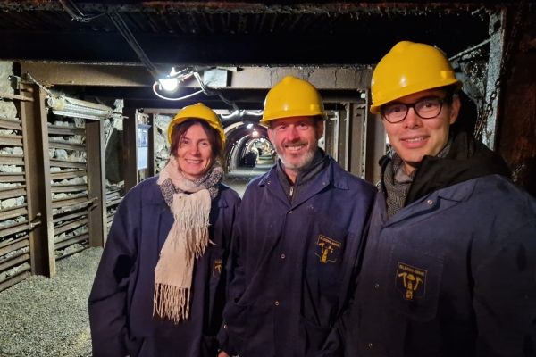
Or you can come and take a look at the geothermal power plant on the Balmatt site in Mol-Donk. VITO is holding an information event for the residents of Dessel, Mol and Retie at the beginning of September. You will receive explanations from the experts and you can ask all your questions about the deep geothermal heat project. The exact date will be announced here later as well as via the municipal information channels.
If you have specific questions, do not hesitate to contact us via aardwarmte@vito.be.
Questions about the seismic measurement campaign?
Feel free to contact Kristine Verheyden, she will be happy to help.