Destination Earth: urban heat maps for Lisbon and Prague
VITO is developing an innovative interactive tool to map urban heat as part of Destination Earth: a flagship initiative of the European Commission to develop a highly accurate digital model of the Earth on a global scale. Following an extensive stakeholder engagement phase, VITO has now delivered new urban heat maps for the demonstration cities Lisbon and Prague

The maps for Destination Earth will be generated by UrbClim, VITO’s physics-based high resolution urban climate model, and will be nested within large-scale atmospheric output provided by the global climate models on Destination Earth’s (DestinE) Digital Twin (DT) platform in the making.
UrbClim will downscale the global climate model results for selected urban areas based on detailed terrain data, providing air temperature and thermal comfort indicators at a spatial resolution of 100m.
In the first phase of the project, a broad stakeholder community was gathered around the topic of urban heat stress. Three main users of the service were identified: the EU Directorate-General for Regional and Urban Policy (DG REGIO) and Destination Earth's two demonstration cities: the city of Prague and the Lisbon Metropolitan Area (LMA). Besides these three main users, a long list of additional stakeholders is involved in the service.
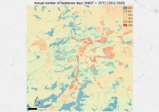
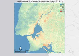
The second phase of the project was initiated by setting up the UrbClim model for the two demonstration cities. Model simulations for the reference period (2011-2020), based on ERA5 reanalysis data, were performed, and consequently used as input to calculate specific urban heat indicators. The resulting maps, as well as city-specific relevant adaptation scenarios, are currently being discussed with the demonstration cities.
In the coming months, climate change and adaptation scenario analysis for heat stress related indicators will be performed for the 2 demo cities. Moreover, the interactive urban heat stress application, nested in DE Climate DT and DE Data Lake datasets, will be developed on VITO’s infrastructure. Full integration of the application on the DestinE System components will be effectuated once these components become available.
The result will be a practical tool for the DG REGIO to assess the unevenly distributed impact of extreme heat events in European cities and for all involved European cities to assess the impact of climate change on urban heat islands and the possible adaptation measures.
Destination Earth is a European Union funded initiative and is implemented by ECMWF, ESA, and EUMETSAT.