WEISS - Water emission inventory support system
WEISS (part of GeoFleX) WEISS enables mapping of the emissions of relevant substances at the level of the various determining emission sources as well as their pathways to the surface water in a very spatially explicit and detailed manner. It supports inventorying, monitoring, reporting, and assessing measures aimed at reducing the pollution of water bodies.
WEISS is een door VITO ontwikkelde software gebaseerd op achterliggende ruimtelijke modellen die de emissies naar oppervlaktewater in kaart brengen en modelleren.
In een eerste stap worden bronnen die verontreinigende stoffen uitstoten geïnventariseerd en in kaart gebracht, met bijhorende gegevens of inschattingen van diens hoeveelheden. Zowel puntbronnen met hun exacte locaties als meer diffuse bronnen van verontreiniging, zoals atmosferische depositie of het gebruik van gewasbeschermingsmiddelen, kunnen in de WEISS tool opgenomen worden.
In een tweede stap modelleert WEISS op een ruimtelijk expliciete manier de transportroutes die de verontreinigende stoffen volgen van de emissiebron naar het oppervlaktewater. Ten slotte komen alle emissies samen in totaalkaarten per bron of groep van bronnen, per stof of groep van stoffen, per knooppunt of groep van knooppunten van de transportroutes, per rastercel of groep van rastercellen zoals administratieve en hydrologische gebieden, ....
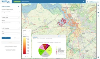
Bekijk het zelf op https://weiss.vmm.be/geoloket
Why use WEISS?
WEISS provides answers to policy relevant questions such as:
- Which sources of pollution are responsible for the observed water quality in river segment x and what is the contribution of each source?
- How have the total emissions and the contribution from the various emission sources evolved over the years?
- How much of the pollution actually ends up in the surface water?
- What share of the pollution comes through the urban wastewater treatment plants? How much through the sewer system that is not yet connected to an active treatment plant? How much via the non-sewage areas? And how much via surface runoff?
- What is the effect of specific sewerage measures on the amount of emissions?
- Where is the investment in additional urban wastewater treatment plants most effective?
- In which areas should additional research be carried out into unknown emission sources?
- …
Applicable to all types of areas
WEISS can be applied to areas of different size: from industrial or rural sub-areas to entire EU Member States, but also from small sub-catchments to large transnational river basins. But, most importantly, WEISS can be applied in data rich as well as data poor conditions. To the effect, it is equipped with a set of algorithms that can be applied under all circumstances. WEISS applications can thus start-up as fairly simple and coarse applications but evolve rapidly as new or better data become available.
We deploy WEISS both as a product and as a service. Parties with a repetitive demand and a desire to perform the recurring analyses themselves can use WEISS as a product, guided by a customised training. Parties with a demand for exploratory and research-oriented analyses and scenarios can use WEISS as an input model in the framework of a service provided by VITO.
Contact us for more information
Would you like to know more about WEISS or the GeoFlex - RuimteModel Vlaanderen toolbox? Please reach out to Karolien, she'd be happy to help you.
