Flood4cast for determining flood risks
How to deal with sudden heavy rainfall and the potential risks of flooding? Where does the rainwater fall and how should you assess local flood risks and define actions to minimize the damage? The Flood4Cast tool uses a smart algorithm that allows a Real Time Forecast (RTF) where and when flooding may occur during sudden heavy rainfall events.
What Flood4Cast has to offer
- Calculation of flood maps
- Real-time prediction of flood risks down to street level
- Analysis of climate scenarios and adaptation measures
- Applicable in data-poor areas
- Useful as a policy-support tool for urban planning interventions
How does Flood4Cast RTF work?
Thanks to smart pre-processing, Flood4Cast RTF can quickly and semi-automatically build a flood model. This is done based on existing geographical data and region-specific sewer system design criteria.
The basis of Flood4Cast RTF is a digital terrain model (topography) supplemented by GIS data of the existing watercourses, the urban drainage and the basic characteristics of the existing sewer system.
The model integrates surface runoff (2D modelling) with a conceptual approach of the sewer drainage system to produce area-wide pluvial flood maps.
Alternative to physics-based models
Computer models that predict flood sensitivity and map water flows are not new. But until recently, they were mainly very detailed physics-based models that require high computing power and are demanding in terms of data availability.
Moreover, this type of flood modelling is not suitable for a fast calculation of the flood risk based on weather forecasting in case of approaching storms.
Flood4Cast RTF meets these needs. Based on a limited amount of data, reliable and real-time predictions of urban flood risk down to street level can be made.
It is also a reliable tool for mapping and evaluating the effects of climate change, urban planning interventions and climate-adaptive measures.
Data-poor conditions
In the development of Flood4Cast RTF, the focus was on semi-automatic and fast model building, even in case of low input data availability. For example, if no data are available on the location of the sewer system, Flood4Cast RTF makes a design of this based on the street plan and other local elements.
Based on free available geographical data (digital terrain model, watercourses, streets), a basic flood model can already be made up. The level of detail of the flood model and the accuracy of predictions can then be improved using more detailed input data or expert knowledge.
The innovative structure of Flood4Cast RTF ensures robust usability with faster calculation times and delivers model results approaching those of other available, more complex models.
Joint project
Flood4Cast RTF is the result of a joint project with the engineering firm Hydroscan. The partnership started in a pilot project for the city of Antwerp to accurately predict flooding in several districts down to street level. The tool was then further developed and fine-tuned in a separate collaboration project between Hydroscan and VITO. Further, the impact of climate change on flood risk was evaluated.
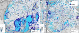
Een proefproject met Flood4Cast voor de stad Antwerpen om de wateroverlast in enkele deelgemeenten accuraat en tot op straatniveau te kunnen voorspellen.
Further developments
Both partners decided to divide the further commercial activities. Meanwhile, VITO's first pilot projects with Flood4Cast RTF are underway in several Chinese and Indian cities.
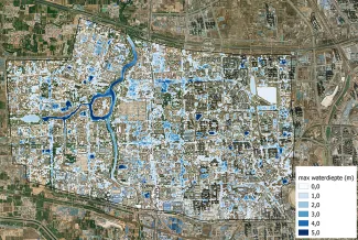
In China, the marketing of Flood4Cast RTF is done through LIBOVITO, VITO's Chinese subsidiary. A first demonstration of the tool was completed there in late 2021. It was done for the Chinese city of Zhengzhou and specifically for an area with a lot of new urban development.
Zhengzhou was hit particularly hard by floods in the summer of 2021, indicating the need for a fast and robust flood model. Flood4Cast RTF can be used there for both real-time forecasting and impact analysis of future climate adaptation measures.
Would you like to know more about Flood4Cast?
Wondering how Flood4Cast can support you too? Contact Johan Ceulemans for an informal discussion.
