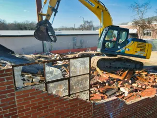
Artificial intelligence lends demolition firms a helping hand
Spurred on in part by the European Green Deal, Flanders is facing a radical renovation operation for its (often outdated) building stock in the coming years. This means that materials being transported away from built-up areas – which are already responsible for the largest waste streams – will need to be collected, sorted, recycled and reused on a large scale. In order for this to take place in as circular a manner as possible, however, the local material stocks need to be known. VITO’s Demolition Guide is the first to offer a more refined assessment of this, based on automatic material recognition.
Material inventories to accelerate circular entrepreneurship
What materials, and in what quantities, weights and shapes, are going into and out of a defined area such as a district, city or region? Based on existing data and a few statistics, a rough assessment can be made of the stock of subsequent inflow and outflow streams. Unfortunately, the resolution for this is quite low, so it is accompanied by rather large margins of error. That means the picture of material stocks remains obscure.
But concrete information on those material stocks (or material inventories) is precisely what is needed for sectors like waste processing and recycling, as well as construction and the transport sector, to start doing business in a more circular manner. ‘In the transition to a circular economy, businesses will need to start reusing and recycling more and more materials,’ says Yoko Dams of VITO. ‘To do so, however, they will need to know what they can expect, so they can focus their activities on that.’
Semi-automatic tool
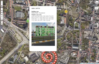
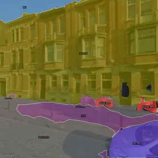
There is already a method for detecting and inventorying asbestos in Flanders. This was partly developed by VITO’s Remote Sensing unit and recognises asbestos roofs and other asbestos construction elements from aerial imagery. A comparable tool for façades and more specifically window profiles is currently under construction. The Demolition Guide was developed with the support of among others Flanders Circular, the Flemish public-private partnership that acts as an interchange for the circular economy. This tool works on the basis of imagery of house and building façades taken from the street, for example by Google Street View®. Artificial intelligence is applied on that imagery to recognise specific construction elements such as windows and window profiles, as well as specific materials.
Market economy studies for renovations
The tool, developed in collaboration with Immoterrae as part of a pilot project that finished late last year, was applied to the city of Leuven and works semi-automatically. Some human intervention is required for selecting the imagery in the tool software, but everything runs automatically after that. The tool’s ultimate output indicates how much of a particular construction element or material is present in a building. In order to arrive at an aggregated result for a ‘scanned’ area and to know how the exact quantities of construction elements and materials are distributed across the local building stock, however, further development is needed. That information may be of interest not only to the mentioned businesses, but most likely also to policy-makers. ‘For example, they can then base market economy studies for renovations on that,’ says Tanja Van Achteren of VITO.
Eighty percent reliable
The tool’s pilot nature means that the Demolition Guide is not quite finished yet – indeed, this is a new development from scratch. There is, therefore, certainly some room for improvement. ‘The technical challenge is quite considerable. The façade of a house or building needs to be clearly visible, for example, and this is often not the case due to parked cars or trees,’ says Van Achteren. ‘In addition, the algorithm being trained on thousands of images of construction elements and materials through deep learning is not perfect. At present, the reliability is around eighty to ninety percent. That means an average of ten to twenty percent of detections are still errors. This problem does not have to be insurmountable, but as a user, you do need to know that.’
Street imagery
The use of street imagery is an asset for the Demolition Guide. After all, besides Google Street View®, cameras can be used on vehicles that are frequently passing through streets anyway, such as refuse lorries, carrier bicycles and cars, and public transport.
In the short term, VITO is aiming to scale up the Demolition Guide to the city level. The evaluation of the completed pilot project will contribute to this. ‘We can now identify the obstacles to further upscaling,’ says Dams. ‘At the same time, we’re aiming to improve
the statistical processing and interpretation of the output data at a district and city level.’
Partners
The Demolition Guide was developed by VITO in close collaboration with partner Immoterrae and stakeholders VCB, Tracimat, FLOOW2 (supplier of Werflink), BOPRO and the City of Leuven.