Flood4Cast helps policymakers anticipate imminent flooding
Hydroscan and VITO developed a tool that allows governments, at whatever level, to assess the flood risks on their territory. It can also be used to simulate the impact of potential policy decisions on flood sensitivities. What started with a question from the Antwerp fire brigade has grown into an efficient water modelling tool that has the potential of being applied worldwide.
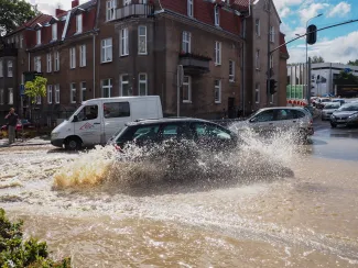
Where and when would flooding be most severe in case of heavy showers?
Five years ago, the city of Antwerp asked whether it was possible to quickly predict, during heavy showers, in which neighbourhoods and streets flooding would be most severe. ‘The question came from the Antwerp fire brigade,' says Jan Bronders of VITO. 'They were looking for a better forecasting method than the conventional method, which was based on the number of incoming emergency calls. Because that way, of course, they were always running behind the facts.'
It led to an initial project involving the city of Antwerp (the fire brigade), the research institute imec, VITO and the Leuven water modelling company Hydroscan. The basis was laid for a tool that can predict in real time where and when flooding might occur during sudden storms, and this down to individual street level. It was the beginning of a development process that would lead to the creation of the Flood4Cast tool, which, in addition to the real-time flood warning tool for individual streets, also includes an innovative concept of area-wide water modelling. This was developed and fine-tuned as part of a separate cooperation project between Hydroscan and VITO.

Specific model construction and quick results
‘Thanks to the model's semi-automatic construction and Flood4Cast's fast calculation time, it is possible to build a new model and perform real-time calculations in a short period of time,' says Guido Vaes of Hydroscan. The model was also adapted to deal with the problem of missing or insufficient data. ‘We thought of a way to build a model even in areas where data are scarce and/or expensive,' explains Koen Hilgersom of Hydroscan. 'If there are no data on sewers, for example, then our tool makes a design of this based on the street plan and other local features.'
Eventually, both tracks came together, resulting in a tool with a specific model structure and with faster calculation times and model results that approximate the output of detailed models (based on extensive surveying).
The development of Flood4Cast has been very ambitious from the start. ‘We aimed for a tool that would be revolutionary and would outperform all existing tools,' says Vaes. ‘For example, it had to be applicable to both urban and rural settings. Until a few years ago, these were two different worlds for water modellers.'
Semi-automatic model-building
Many of Flood4Cast's advantages can be attributed to the semi-automatic model-building process, which takes no more than a few days. With conventional modelling software, this can easily take months or even years. And perhaps the most important USP is that the models can be updated easily and quickly, because the situation (e.g. additional buildings) is constantly changing.
In order to increase the calculation speed, the level of detail was somewhat reduced, achieving an optimal balance with the accuracy of the prediction results. Another advantage of the rapid model construction and ditto calculation times is that Flood4Cast is also very useful as a simulator. Vaes: 'Policy makers can thus study the impact of future potential scenarios and spatial planning decisions on flood sensitivities simply by simulating them.'
Flood4Cast, a collaboration between Hydroscan and VITO
The development of Flood4Cast is thus the culmination of a collaboration between Hydroscan and VITO. Originally the tasks were divided in such a way that Hydroscan dealt with modelling in urbanised areas, and VITO with rural ones. ‘Hydroscan has long been specialised in urban water management; we could add little to that,' says Bronders. Yet during the development, the division of tasks was not strictly followed. ‘It was a joint effort from start to finish.'
When it comes to marketing the tool, in other words the commercial part of the project, things are different. Here, clear, strategic agreements were made about who does what. It was agreed that VITO will market the tool in China and India, and Hydroscan in the rest of the world.
Offering the tool as a service
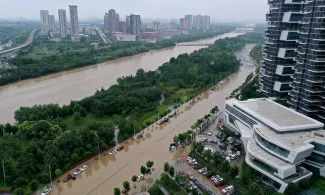
In China, this marketing is done by LIBOVITO, the Chinese subsidiary of VITO. A first demonstration of the tool was completed at the end of 2021. ‘That took place in Zhengzhou, in a part of the city with many urban developments,' says Michel Craninx of VITO. Zhengzhou is the capital city of Henan Province (central region of China). 'The challenge we had there was to build a model with low availability of input data, but also to make real-time predictions. We have now explored both in this first demo phase. We are now looking at how we can use Flood4Cast even better in the future in regions with low data availability.'
Modelling with Flood4Cast for the whole of Flanders
In Flanders, HydroScan offers the tool as a service under the name Flood4Cast Masterplanner. ‘The model is created by us while our customers receive the flood maps with the results of planned climate adaptation and remediation measures,' says Vaes. ‘Authorities, at whatever level, can already contact us for this. In addition, Hydroscan's Flood4Cast Real-time Alerter is a tool that supports authorities and emergency services by predicting imminent floods up to several hours in advance and down to street level. Interest is likely to be high, especially after the devastating floods in the summer of 2021. Recently, Hydroscan was asked by a Flemish city what would happen if the 'water bomb' that caused all that misery last year were to fall in Flanders. For a river near Aarschot we checked whether Flood4Cast would have predicted the same impact during the floods as actually occurred. 'We did this exercise using drone images from the Flanders Environment Agency (VMM) and precipitation data from that period. On the flood map, we saw almost the same flood impact.'
And this is how a specific request from the Antwerp fire brigade culminated in an efficient water modelling tool that has the potential to conquer Flanders and the rest of the world in the short term. ‘We are currently completing the modelling with Flood4Cast for the whole of Flanders,' says Vaes, 'a huge undertaking given that more than a hundred river basins are involved. These modelling results will also be used by the VMM in its Climate Portal, in which climate scenarios for Flanders are calculated.
Although Hydroscan and VITO have slightly parted ways since Flood4Cast was launched, they still keep each other informed of developments. Bronders: 'We have a meeting at least every three months to share new knowledge and exchange our lessons learned.'