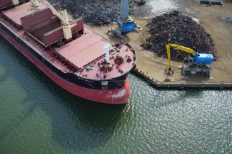
High precision ship positioning with drones
The Port of Antwerp is one of the largest ports of Europe. A massive number of ships arrives every day to load and unload as quickly as possible. No time to waste! All these ships have to be allocated an area to load or unload their cargo as quickly as possible. But this is easier said than done! Up till now, port authorities need to rely on spaces that are already allocated and the available AIS (Automatic Identification System) data such as unique identification, position and length information which unfortunately isn’t always as reliable.
That’s why we teamed up with the Port of Antwerp and DroneMatrix to see how we can use remote sensing to determine a ship’s position with high precision in order to help port operators to improve planning and avoid ships being unable to moor at the assigned berth and losing precious time. Discover how drone-based remote sensing allows us to successfully detect, position and dimension ships at the quay walls.
Blog post by Pieter-Jan Baeck
OPTIMIZING THE SHIP MOORING POLICY
In an international port like the ‘Port of Antwerp’ an efficient and smoothly functioning mooring policy is crucial. Handling approximately 195 ships each day, the port authority has to be able to assign free mooring spaces to incoming ships keeping in mind many different aspects such as the ships already present, the dimensions of the incoming ships, cargos that needs to be loaded or unloaded, etc.
But what if the already allocated spaces aren’t used properly or aren’t up-to-date? And what if the AIS (Automatic Identification System) data is missing or incorrect? Unfortunately, there is often an offset between the imposed and actual mooring places due to wrong GPS offset information or incomplete ship dimensions. In the worst case this can lead to incorrect planning and incoming ships that are unable to moor at the requested berth, loosing precious time.
The ‘Port of Antwerp’ therefore challenged us to find an innovative drone-based remote sensing solution to optimize the ship mooring policy. Our answer was twofold. We used drone-based inspection techniques in combination with a photogrammetric point cloud image processing solution to meet these criteria:
- Accuracy: the data must have a precision of 50 cm or better
- Near real time: the results must be available within one hour
- Workable procedure: the solution must have minimal operational constraints
DRONE-BASED CORRIDOR MAPPING
The Port of Antwerp has about 120 km of useable quay walls. In order to cover such distance, drones give us several advantages. First, by flying in a linear pattern (a.k.a. corridor mapping) we can easily cover tens of kilometres of quay wall in one single flight. The drone flight plan is also extremely flexible: it can skip unnecessary zones based on live information. To execute the drone flights in this case, we teamed up with DroneMatrix and focussed on one specific dock called the ‘Vrasenedok’.
Each campaign starts with determining the most suitable drone platform and camera. In this case we used DroneMatrix’ drone station ‘Yacob’ to perform photogrammetric missions. Multiple flight scenarios were carried out to see which combination of flying height, distance to the quay wall and camera viewing angles is most suitable for this case. It was important to keep a safe distance of 60 metres from the ships, to not exceed the legal flight altitude of 90 metres and let the ship cover as many pixels as possible in the final imagery.
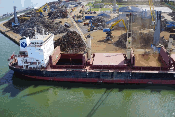
During this test we collected drone data with centimetre resolution and covered 1300 metres of the ‘Vrasenedok’ quay wall including 87 reference bollards and 12 ships, ranging from small inland tankers (30 metres) to larger bulk carriers (200 metres).
Since we were very eager to push for the best absolute positional accuracies, we also needed accurate camera calibration parameters:
- We performed a camera calibration flight to determine the sensor and lens distortions
- The bollards on the quay wall were used as control and verification points. This allowed us to both determine and verify the measured accuracies.
A PHOTOGRAMMETRIC POINT CLOUD SOLUTION
As soon as all flights have been carried out, the data is being processed by a dedicated image processing workflow, which can detect, position and dimension the ships at the quay walls.
In a first step, we generated point clouds by using a photogrammetric approach: each individual image needs to be matched with its surrounding images. Together with the camera calibration information, we can precisely estimate the position and orientation of all images and create a coloured 3D point cloud of the region of interest to automatically extract the ships. By using advanced filtering methods, we can eliminate the quay walls, the background scenery and even the water. Only the ships remain!
As soon as all moored ships are available in the form of a 3D point collection, the bow and stern (the two most extreme points in the longitudinal direction of a ship) can easily be detected and projected on the quay wall (for the Vrasenedok, the bollards were equally spaced every 20 metres). Once this information is gathered and processed, the image processing workflow gives us useful feedback to:
- Determine accurate and precise position of ships
- Detect mismatches within the planning software
- Correct AIS data for future references
- Improve ship mooring policy
- Reduce unforeseen ship waiting times
Bob Spanoghe, Innovation Platform Manager at the Port of Antwerp, explains why this is important for them: “The most important thing for us is to determine berths as accurately as possible with less than 50 cm accuracy in order to ensure that different ships can safely berth next to each other. This especially in relation to the correct configuration of mooring lines. Including an automatic and accurate ship positioning workflow in our day-to-day operations could mean a solid optimization of our operational excellence. Certainly if we could use drones for this, because they could collect the data in the fastest and most efficient way."
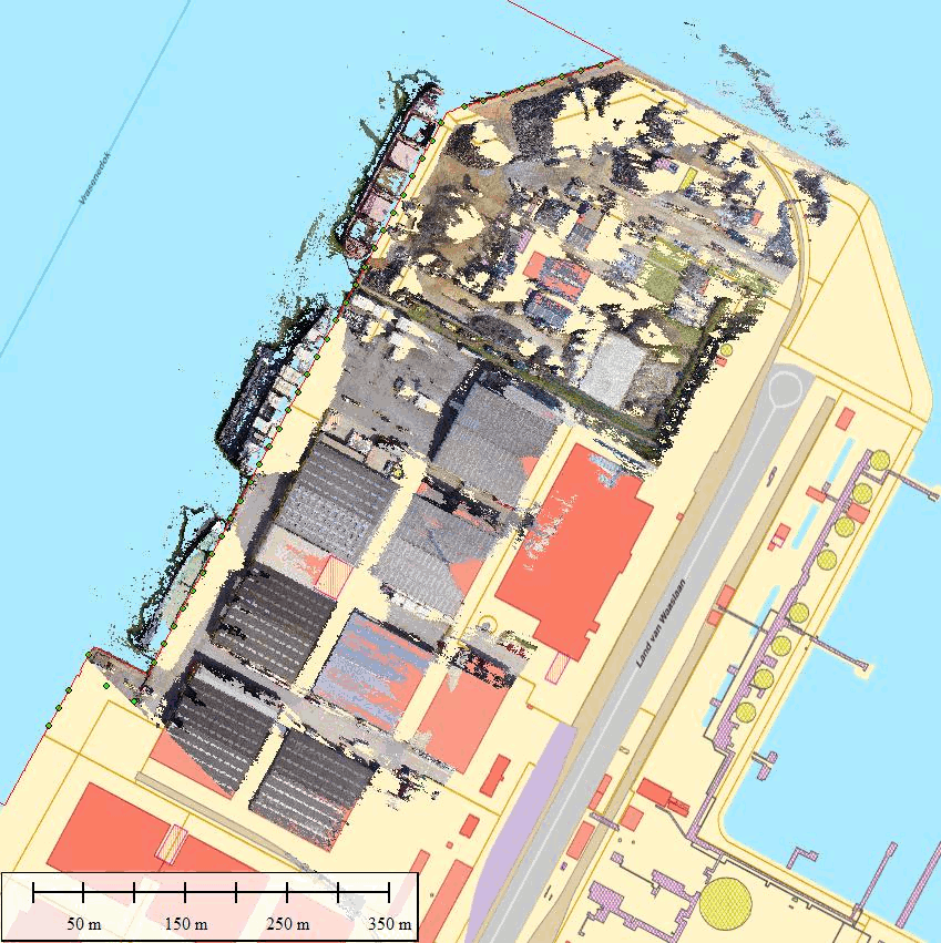
Ship detection at the Vrasenedok: intelligent filtering of the photogrammetric point cloud
VALUABLE INSIGHTS FOR PORT AUTHORITIES
This use case showed us that this drone-based remote sensing solution can support port authorities to obtain more precise ship position data, and choose optimal mooring spots for incoming ships and avoid losing precious time. The results exceeded the preliminary expectations. The DroneMatrix flight campaign was able to get positional accuracies down to 5 centimetres (remember that 50 cm was initially requested) and the processing workflow only requires a couple of minutes which meets the near real-time requirements.
Point cloud intelligence is an extremely interesting topic in the geoinformation world, and we were happy to introduce this technology for precise inspection in port context. It gives us the opportunity to extract much more from a ship than e.g. the bow and stern! Enough detail is available to characterize each ship and extract the length and width with cm-level accuracy. Interested to learn more or see what it can do for your business? Don’t hesitate to contact me.