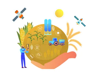
Monitoring grain crops from space, season by season
Having been commissioned by the European Space Agency (ESA), VITO has developed a monitoring tool that can identify agricultural activities (the growing of specific crops but also measures such as irrigation) down to the level of individual fields. The WorldCereal tool covers the entire planet, and the maps it generates can be updated every growing season - which is a first.
The remote sensing experts at VITO are increasingly working on a global scale. At the end of 2021, they finalised a new world cover map in the context of the ESA-WorldCover project. The level of detail and precision of the map were unprecedented. The WorldCover map was created based on images from Sentinel 1 and 2, two satellites that are part of the European Earth observation programme Copernicus.

Agricultural map with updates
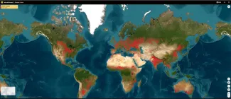
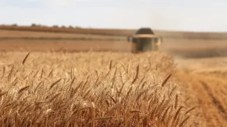
At the end of 2022, VITO achieved yet another first. It developed a monitoring tool, WorldCereal, which allows to monitor the cultivation of key food crops such as wheat and corn, as well as agricultural activities such as the irrigation of fields, around the world. Here too, these ‘products’ can now be monitored with unprecedented resolution, down to the level of individual fields. What is more, the WorldCereal maps are updated after every growing season. And this update is rapid: if, for example, the wheat and corn season in Western Europe ends in September, the updated map can be ready as early as October. The updates are automatic, based on global crop growth calendars: when a corn or wheat season ends in a given region, the analysis of that season starts. In November 2022, VITO presented the definitive WorldCereal tool at a gathering in Geneva.
It was no coincidence that the presentation took place in Switzerland. Indeed, Geneva is home to GEOGLAM, a partnership for the monitoring of agricultural activities that has closely followed the development of WorldCereal. GEOGLAM is also a potential future user of the tool. The gathering marked the temporary closure of the project WorldCereal for VITO, but also for ESA, which funded the project.
The software behind the tool is open source, which is very interesting for prospective users. ‘But there are other costs involved when using the tool, such as for storing data and renting server time,’ explains Sven Gilliams of VITO. Several other prospective users introduced to WorldCereal in Geneva include the UN Food and Agriculture Organization (FAO), the Agricultural Market Information System (FAO-AMIS), the European Copernicus programme and the World Resource Institute (WRI). Whoever the operational end-user is will likely be decided later this year.
The WorldCereal tool has been delivered to the European Space Agency (ESA) for final review. The WorldCereal consortium aims to release the dynamic system with seasonally-updated cropland and crop-type maps by Spring 2023 for the general public.
Countering food speculation
There are a broad range of potential applications for the WorldCereal tool. An organisation like FAO-AMIS, for example, could use it to counter speculation on food crops, by timely releasing objective data on their availability (e.g. harvest forecasts). It could also be useful in the fight against global warming. The WorldCereal maps can help in monitoring variations in greenhouse gas emissions between different types of agriculture and crop types - something that can help countries in drawing up their mandatory ‘CO2 accounts’.
One of VITO’s strong points that was particularly useful in the development of the WorldCereal tool was the identification and classification of crops based on satellite images. The experts at VITO developed methods to identify winter and spring wheat, for example, and to differentiate it from other cereals. The algorithms for this have been extensively tested and improved in recent years, in the context of various ESA and EU projects.
Of course, the complete WorldCereal tool was also extensively tested before it was released. An important aspect in this regard were tests on a large scale, which included demonstrations of WorldCereal products in five different countries across three continents. These demonstration regions were selected in collaboration with users and based on elements such as agricultural type, plot size and average cloud cover. But the importance of countries in global cereal production was also looked at, including regions with reduced food security. The selected countries were Argentina, France, Ukraine, Spain and Tanzania. In total, the demonstrations covered 1.5 million square kilometres of agricultural land. The results of the monitoring were compared with reference data that had not yet been used during the development of the WorldCereal tool. The comparison showed how accurate the monitoring was.
For the five countries combined, the total annual area of agricultural land was mapped with an accuracy of almost 90 %. In France and Ukraine, the monitoring of individual products was the most accurate (more than 95 %), while in Spain and Tanzania it was somewhat lower. In these countries, there were overestimates of the extent of agricultural fields, because they were sometimes mistaken for natural vegetation such as grassland.
Although VITO, as the developer, and ESA, as the project financier, are now handing over the tool, there are possibilities for a follow-up phase. ‘The user will most likely need support in using the tool,’ explains Gilliams. ‘Of course, as developers, we are ideally placed for that.’ In addition, the tool can also be improved and further refined, for example to identify even better and more crop types. This follow-up research and development are of course also on VITO’s radar.
VITO (Belgium) is the prime contractor of the World Cereal consortium together with CS (France), eLeaf (The Netherlands), GISAT (CZech Republic), International Institute for Applied Systems Analysis (Austria), University of Strasbourg (France), University of Valencia (Spain) and Wageningen Environmental Research (WENR) (The Netherlands).