Near real-time info on land cover changes help monitor impact on climate and biodiversity
At the end of 2021, the WorldCover project of the European space agency ESA announced a scoop. For the first time, there was a detailed land cover map that spanned the entire surface of the earth. Equally important is the speed with which the map - which shows the land cover during the year 2020 - was developed. As a result, changes in land cover can now be spotted in near real time. And this enhances the monitoring of the impact of those changes on climate, biodiversity or food security.
In the historic Paris climate agreement, which dates back to 2015, it was agreed that countries would keep meticulous records of their efforts and progress in the fight against climate change. These so-called nationally determined contributions (NDCs) include national reductions in greenhouse gas emissions and adjustments to the impact of climate change. All these individual NDCs are periodically collected and processed in a global inventory of the climate effort, called the global stocktake, which is then used to assess the collective progress globally.
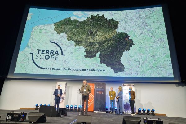
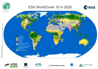
WorldCover
Producing these NDCs requires countries to keep complicated accounts. An exercise that only yields good results if it is based on objective, reliable input data. That is why the European Space Agency ESA launched the WorldCover project in 2019. The aim? To develop a highresolution map of land cover worldwide for the first time. ‘Land cover plays a key role in the calculation of greenhouse gas emissions,’ says Ruben Van De Kerchove of VITO. ‘The simplest example is probably that of a forest that absorbs CO2 from the air or a grass meadow where cows produce methane gas.’ Thanks to its years of experience in the development of land cover maps, VITO was selected by ESA, together with other partners, to carry out this project.
At the end of 2021, the WorldCover project was finished and VITO was able to release the new, global land cover map. With the unprecedented level of detail (up to 10 metres accuracy), the development of this map is a true milestone. It shows the global land cover for the year 2020, and precisely because it has taken less than a year to produce, it is a powerful demonstration of how it is possible to respond more quickly. Sven Gilliams of VITO: ‘I remember when a similar land cover map for the year 2000 was only ready in 2005. Now it took less than a year, and in fact we have proven that it can even be done in less than three months.’ VITO can take credit for this rapid development because, in addition to general coordination, its Remote Sensing unit within WorldCover was also responsible for building the map based on images from the European Sentinel-1 and -2 satellites. ‘We were able to cut down on development time considerably by, among other things, automating the algorithms for image processing and thus significantly speeding up the process.’
Now that it has been demonstrated that global and detailed land cover maps can already be developed in the first few months following an observation year, it will soon be possible to compare successive maps. ‘Changes in land cover are very important. These changes do not only influence the greenhouse gas emissions in an area (think of forest that has to make way for agricultural land) but they can also have an impact on local biodiversity and food security,’ Gilliams says.
Ecosystem accounting
The land cover map can be seen as a basis to which specific data are then added, depending on the application. Within the ongoing WorldCereal project, also from ESA, this involves information, such as the crop type or the level of irrigation in an agricultural area. ‘Greenhouse gas emissions also vary between different forms of agriculture and between different types of crops,’ says Gilliams. ‘So this kind of information is also relevant in the context of monitoring the climate promises made in Paris at the time.’ And, of course, land cover maps with detailed agricultural data are also important for monitoring food security, whether globally or in specific areas. In that context, the WorldCereal project - for which VITO is also responsible - completed a successful demonstration at the end of 2021 in which agricultural crops were monitored in five different countries during the growing seasons in 2019, and VITO is now working hard on the global follow-up of crops.
Given the speed at which they can now be developed and how detailed they are, global land cover maps also prove to be of high value for monitoring biodiversity - that other crisis threatening our planet. They allow for the accurate identification of natural resources (not only in the traditional sense of raw material reserves, but also, for example, biodiversity hotspots and ecosystem services, such as clean air or water supply) in an area and their changes. Call it nature’s accounting. ‘In technical jargon, we speak of natural capital accounting (NCA), or ecosystem accounting,’ says Bruno Smets of VITO. ‘By combining land cover maps with other socio-economic data, we gain insights into the size and environmental quality of the ecosystems and their services in an area. With additional data on habitats we can, for example, investigate biodiversity. Or we can study certain ecosystem services in more detail by projecting flood risks onto the map, for example.’
As is currently the case with NDCs on climate, countries (or at least EU Member States) may soon have to start keeping such national ecosystem accounts - possibly as early as 2024. Eurostat, the statistical office of the European Commission, is currently laying down the rules for this. And VITO is also working on this. ‘We are helping Eurostat set up an NCA system by developing guidelines and tools for reporting these natural accounts,’ Smets says.
The World Resources Institute (WRI) is a user of WorldCover
With these new, freely available, global land cover data at 10-metre resolution, we are taking a big step forward. They give us an insight into how land contributes to mitigating climate change, meeting our food needs and supporting biodiversity. The way land is used plays a crucial role in this and is therefore also an essential part of the solution. Moreover, land is a finite resource, which makes a better understanding of where and how land is used elementary for the next assessment of trends and the definition of action points for climate, food security and biodiversity.
WRI - Fred Stolle, Deputy Director Forest programme & Director Land cover monitoring