Sustainable Bird Conservation in Agricultural Areas with BirdWatch by VITO
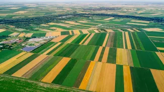
Farmland and meadow birds - such as the lapwing, curlew, and skylark - are disappearing at an alarming rate from our agricultural areas in recent years. Not only in Flanders, but throughout Europe, in fact. This is mainly because our agricultural landscapes lack certain features that make them suitable for birds. In the European BirdWatch project, the Data Science Hub of VITO and the MooV team collaborate to determine the optimal habitat based on satellite images and other open data.
Billions of euros have already been spent on conservation measures. Yet, the birds in agricultural areas are faring very poorly. Our agricultural landscapes are not designed to accommodate nesting and breeding birds. Additionally, different bird species have different needs. Sometimes these needs overlap – for example, the curlew requires grassland while the lapwing can choose between fields or grassland – and sometimes they are conflicting. The shrike needs hedgerows and wood edges, while the curlew avoids them as much as possible.
The question is how we can optimize our meadows and fields to remain agricultural areas while meeting the needs of birds. Sometimes the interventions are simple, such as clearing or planting hedgerows. Other times – and usually – it is more complex.
BirdWatch, an initiative supported by the EU Space Programme Agency (EUSPA), is developing a web-based service that links bird habitats to the suitability of agricultural land in the EU. This will allow stakeholders to assess the suitability of a specific environment immediately, making it easier to monitor and predict biodiversity development in the region. Furthermore, BirdWatch aims to propose ecological interventions that are available for the respective region, taking into account both the economic consequences and the habitat preferences of local farmland birds.
BirdWatch measures landscape features on agricultural land using satellite imagery. The Copernicus program provides continuous data capturing all significant changes on the ground. Within VITO, BirdWatch is a collaboration between VITO's Data Science Hub and the MooV team in VITO's chemistry unit. Together, they perform spatial optimisation in this project, considering not only ecological but also operational and financial constraints.